California RaftingSouth Fork American River - Class IIIMiddle Fork American River - Class IVCombination Trips

|
How to get to the American River
DRIVING DIRECTIONS TO EARTHTREK EXPEDITIONS Click here for Google Maps directions
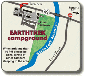
Our South Fork, Middle Fork and North Fork American River trips all meet at the EARTHTREK EXPEDITIONS CAMP in Lotus on the South Fork American. Following are driving directions to our camp. From Southern California (approximately 7 hours driving time): Take I-5 north to Sacramento and follow the directions below from Sacramento. From San Francisco Bay Area (2- 2 1/2 hours driving time): Take I-80 east to Sacramento and follow the directions below from Sacramento. From Redding and the Sacramento Airport: Take I-5 south to Hwy 50 east (freeway sign on I-5 directs you to Fresno) and follow the directions below from Sacramento. From Sacramento (1 hour driving time): Take Hwy 50 east towards Placerville/Lake Tahoe. Drive about 34 miles to Ponderosa Road (Exit 37)and exit the freeway. At the freeway offramp stop light turn left and cross over the freeway. At the second stop light, just past the freeway, turn right on North Shingle Road. Continue about 11.5 miles (the road becomes Lotus Road at mile 5) until the road deadends at Hwy 49. Turn left on Hwy 49 and cross over the American River Bridge (as you cross over the bridge you'll see our camp and grass lawn on the left). Turn left at the SECOND DRIVE into River Park Village and follow the road down to our gravel parking lot which is behind River Park Village. From South Lake Tahoe: (1 1/2 hours driving time): Take Hwy 50 west over Echo Summit to Placerville. Turn right (north) on Hwy 49 (Spring Street) and drive about 9 miles thru the historic gold discovery site in Coloma and cross over the American River Bridge. Past the bridge turn left at the SECOND DRIVE into River Park Village and follow the road down to our gravel parking lot. From Reno or North Lake Tahoe (2-2 1/2 hours driving time): Take I-80 west to Auburn and then take Hwy 49 south. You will cross over the North Fork of the American and then climb to the community of Cool. From Cool,6 miles. Continue on Hwy 49 about 10 more miles to River Park Village, which will be on your right (do not cross over the bridge). Turn right at Yossum's Pizza and follow the road down to our gravel parking lot. When you arrive at our camp please check in at our camp store or follow the directions posted on our bulletin board in camp. Here you will find information about any camping gear you may have rented and where it is located. If you are arriving late please observe our quiet hours from 10 PM to 7 AM. If you have an RV you are welcome to park in our lot and sleep in your vehicle but there are no hook ups and please no generators during our quiet hours from 10 PM to 7 AM.
|
INSTANT RESERVATIONSAdd to an existing reservation:Check Availability:


|
||||||||||||||||||||||||||||||||||||||||||||||||||||||||||||||||||||
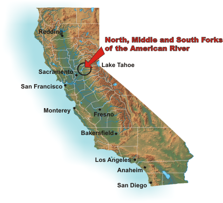 There are several ways to get to the American River. The easiest and most popular means of transportation is to drive your own car. Driving directions are detailed below.
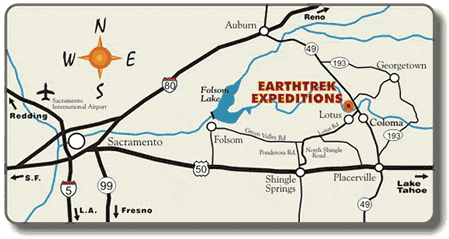
 Call 800-229-8735

PO Box 1010, Lotus, CA 95651-1010
(530) 642-1900 (800) 229-8735
Copyright © 2024 EarthTrek Expeditions - All rights reserved - privacy policy - site map
Built by Portline Website Builders. Copyright © 1993-2024. Portline, Inc. All Rights Reserved.